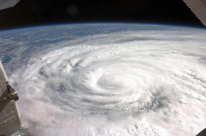
The world’s oceans have absorbed the overwhelming share of the excess heat trapped by greenhouse gases, and the consequences are now surfacing in the one place forecasters watch most anxiously: the breeding grounds of tropical storms. Sea surface temperatures across the main Atlantic development region have run at or near record levels in recent seasons, and researchers say the extra warmth is changing what a hurricane can do — and how quickly it can do it.
Fuel in the water
A tropical cyclone is, at heart, a heat engine. It draws energy from warm surface water, and the warmer and deeper that layer of warmth, the higher the storm’s ceiling. Scientists at the National Oceanic and Atmospheric Administration note that ocean heat content — not just the temperature at the surface — determines whether a storm passing over a patch of sea will find fuel all the way down or churn up cold water and weaken itself. When the deep layer is warm too, storms can intensify explosively.
That is the phenomenon behind rapid intensification, defined as a jump of at least 30 knots in wind speed within 24 hours. Episodes that once were rare have become a recurring feature of recent seasons, compressing evacuation timelines for coastal cities from days to hours. A storm that goes to sleep as a tropical depression can wake forecasters as a major hurricane.
What the observations show
Satellite monitoring, much of it curated by NASA’s Earth Observatory, shows marine heatwaves becoming more frequent and longer-lasting across the world’s basins. The effects ripple beyond hurricanes: warmer water expands, lifting sea levels; it bleaches coral reefs; it shifts the fish stocks that coastal economies depend on — themes we follow across our Sciences coverage and in the reporting gathered in our News section.
Attribution studies now routinely quantify how much more likely a given storm’s rainfall or peak winds were made by human-caused warming. The signal is clearest for rainfall and for the proportion of storms reaching the highest categories, even as the total number of storms shows no simple trend.
Forecasting fights back
The good news is that prediction is improving almost as fast as the problem. Higher-resolution models, ocean gliders feeding real-time temperature profiles, and machine-learning systems trained on decades of storm data have sharply reduced track forecast errors. The challenge that remains is intensity: telling a city not just where a storm will land, but how strong it will be when it gets there — with the ocean still loading the dice.
The warming is not confined to hurricane country. The Mediterranean now produces medicanes — storm systems with tropical characteristics once considered impossible at that latitude — while the Arabian Sea, historically quiet in the pre-monsoon months, has produced a string of severe cyclones feeding on exceptional heat. Each basin writes the same sentence in a different dialect: warmer water, more energy available, higher rainfall totals when storms stall over land.
Insurers and city governments are responding in the only language available to them — price and concrete. Premiums in exposed coastal regions have climbed sharply, building codes are being rewritten for wind and flood loads once classed as once-in-a-century events, and managed-retreat conversations have begun in communities that a generation ago expected to pass their shoreline homes to grandchildren. The ocean’s heat is an abstraction on a chart. On the ground, it is becoming a line item.